
VISIT - field info
 SEE THE PHOTOS
 CONTACT US
Airport managers reserve the right to refuse or terminate access at anytime.
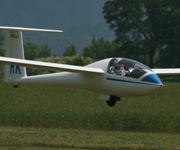
Airfield open to FAA registered aircraft with clearly visible markings from sunrise to sunset. Do not interfere with glider operation.
No low flying. Show goodwill toward our gliderport neighboors.
NO PPGs / No Powered Ultralights
There are many possibilities for off-field Camping & lodging nearby.
| FAA IDENTIFIER | 92A |
|---|---|
| LOCATION | 4 miles NE of Benton, TN |
| LATITUDE / LONGITUDE | 35-13-35.264N / 084-35-05.758W |
| ELEVATION | 770 ft. / 235 m |
| RUNWAY | 3/21 |
| DIMENSIONS | 2600 x 200 ft. / 792 x 61 m |
| SURFACE | turf |
| TIME ZONE | UTC -4 (UTC -5 during Standard Time) |
| VARIATION | 02W |
| TRAFFIC PATTERN | glider/West (riverside) power/East (mountain side) |
| SEGMENTED CIRCLE | No |
| USE | private, open to the public |
| ACTIVATION DATE | 02/1974 |
| SECTIONAL | Atlanta |
| CTAF | 122.9 |
| GLIDER FREQ | 123.3 |